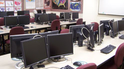
This computer laboratory is well-equipped for computer cartography, GIS, geospatial data analysis and word processing. The lab includes 29 work stations, two laser printers (black and white, as well as color), a scanner and up-to-date software for mapping and other projects.
GIS at Calvin University
GIS has been taught at Calvin University since the mid-1990s. With the introduction of faculty specializing in GIS and Remote Sensing, the program has grown tremendously.
Students can take three geospatial courses at Calvin University. Introduction to Geographical Information Systems and Cartography (GEOG 261), Advanced GIS (GEOG 361) and Remote Sensing of Earth (GEOG 362). Students learn using state-of-the-art software in geospatial thinking and technology.
James A. Clark Geospatial Laboratory
Our geospatial lab is used by GEO students for spatial analysis projects of all kinds. Our PC-based lab has a variety of advanced hardware and software.
- Dual flat-panel monitors
- 8 GB of RAM per machine
- Optical mouse
- 18 GB of workspace
- B&W and color laser printers
Our software includes the most up-to-date versions of:
- ArcGIS
- ArcMap
- ArcCatalog
- ArcScene
- ArcGlobe
- 3D Analyst
- ArcScan
- Data interoperability
- Geostatistical Analyst
- Maplex
- MPS Atlas
- Network Analyst
- Publisher
- Schematics
- Spatial Analyst
- Survey Analyst
- Tracking Analyst
- Military Analyst
- Business Analyst
- City Engine
- Erdas Imagine
- Google Earth Pro
- Rock Works
- SPSS
- Microsoft Office
- Adobe Products
Sample of GIS applications built in Advanced GIS (GEOG 361) Spring 2015
- Sushi in Grand Rapids
- International Eating in Grand Rapids
- Grand Rapids Environmental Restoration
- Gluten Free Grand Rapids
- Grand Rapids Best Burgers
- Kent County Parks
- Grand Rapids Breweries
- Historic Places in Grand Rapids
- LEED Certification in Grand Rapids (I)
- LEED Certification in Grand Rapids (II)
- U.S. Foreign Aid & Democracy
- Grand Rapids Bie Culture Expansion


