When superstorm Sandy pushed a torrent of water into the New Jersey coast and New York harbor, obliterating beaches and boardwalks, filling subway tunnels, destroying infrastructure, wrecking homes and lives, Jesse Feyen ’97 was saddened, but not surprised.
“We predicted the storm surge accurately,” he said. “That’s a great accomplishment.”
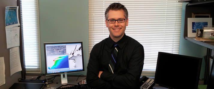
Feyen is a storm surge expert at the National Oceanic and Atmospheric Administration (NOAA). Working closely with the National Hurricane Center, he and his team spent the days before Sandy made landfall running computer models that predicted how much water would go where.
“It was a challenging storm because we have some models tuned to predict hurricanes and some models designed to predict extra-tropical systems,” he said. “Sandy combined both.”
Plus, the parameters that influence storm surge—wind strength, how fast the storm is moving, its size and angle of approach, among others—can change by the hour.
“One thing that helped our prediction was that we had a new model, developed by my team, up and running for Sandy,” he said. “It’s the first model that combines the effects of storm surge with the tides, and tides are very significant in the Northeast.”
So NOAA’s storm surge team knew the impact at the lower tip of Manhattan would be intensified because the storm hit there at high tide. Water at the Battery rose to 11½ feet above sea level.
That the surge prediction was this accurate is due in good measure to a project NOAA initiated in 2009 called the Storm Surge Roadmap. Feyen is the project’s manager.
“The Roadmap is a portfolio of projects from different offices, all designed to improve the accuracy and clarity of storm surge information,” he explained. “My job is to help the various experts work together to make progress we can’t make if we each work in our stovepiped areas.”
It’s a job grounded in his Calvin education, Feyen noted, because “a liberal arts education teaches you a wide range of ways to view the world and analyze problems.”
For example, one of his main job goals has nothing to do with the physics of weather or more accurate modeling.
“As a scientist, I realized that improving the science and technology wouldn’t, by itself, lead to the outcome we all want—keeping people safe. We need to be able to take our data and translate it into a form the weather forecaster can understand and interpret, so that he or she can communicate it effectively to an emergency manager and broadcast media, who need to be able to communicate it clearly to the general public, so the public understands the risks and can take action.”
Adding to the challenge of communicating complex information, Feyen said, is that “nobody is getting a significant storm surge event regularly. So forecasters and decision makers are dealing with phenomena and technology they don’t use often. Making the information easy to understand is one of my main goals.”
To accomplish that, Feyen calls on social scientists who advise on the best descriptive words to use, the size and color of graphics and other communication subtleties.
Savvy weather communication is more urgent now than ever, Feyen said. With sea levels rising and more people living near the coasts, the impact of storms is only going to intensify.
“Sandy reinforces how important it is to improve both our models and our communication of the hazards so that we can prevent damage and loss of life in the next event. That’s a big motivator for me.”